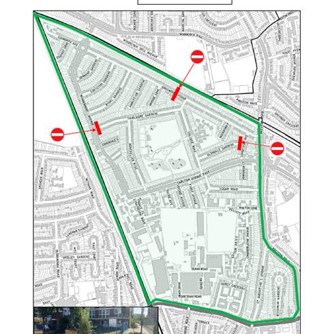
Measures have been carefully designed to make it safer to walk and cycle in the area and to stop rat-running traffic from polluting residential streets. The idea is that the planters and bollards, which discourage non-local traffic, will work together with the new School Street at Preston Park Primary to create a healthier neighbourhood.
Due to the increased COVID-19 infection rates and high numbers of emergency calls we arranged replacement of the lockable bollards with temporary barriers at restrictions to enable quicker access for the emergency services
As part of the programme, we invited national charity, Living Streets, to lead on a period of community engagement from July through to September 2021, allowing residents living in the Healthy Neighbourhood areas to express their views about how they might be affected and to help shape the scheme.
View the Community Engagement report
View the Monitoring Review report

Traffic surveys and air quality
Monitoring data
As part of the trial we will be conducting traffic surveys and monitoring air quality throughout the six months. The following table will be updated with new data as it is collected.
Average number of motor vehicles per day
Table below shows the average number of motor vehicles per day on the named road before the trial and the throughout the 6 months.
| Road name | Before Trial | After 2 months | After 4 months | After 6 months |
|---|---|---|---|---|
| Woodcock Hill | 11,573 | 8,092 | ||
| Thirlmere Gardens | 351 | 242 | ||
| Windermere Avenue | 1,799 | 1,650 | ||
| Grasmere Ave E/O Longfield Ave | 1,233 | 1,369 | ||
| Grasmere Ave E/O Rydal Gdns | 1,109 | 886 | ||
| Montpelier Rise | 346 | 376 | ||
| Preston Road | 16,349 | 12,749 | ||
| Carlton Avenue East | 3,068 | 2,583 |
NO2 concentrations
Table below shows the NO2 concentrations(ug/m3) on the named road before the trial and the throughout the 6 months.
| Road name | Before Trial* | After 2 months** | After 4 months | After 6 months |
|---|---|---|---|---|
| Carlton Avenue East | 32.88* | 31.74 | 22.47 | 21.00 |
| Grasmere Avenue | 32.81* | 27.55 | 18.9 | 17.01 |
| Preston Road | 42.17* | 37.97 | 36.35 | 36.96 |
*Please note that these baseline figures are taken from the London Atmospheric Emissions Inventory 2016 which provides modelled annual mean concentrations for NO2 at a 20m grid resolution. 2016 is the most recent year for which this data is available for. If a location is situated between two points, an average has been taken. Data available online.
**Monthly concentrations are not yet adjusted in accordance to the LLAQM technical guidance and are therefore subject to change. Read more information about air quality data.